Next, we provide you with some of the hiking routes that can be done in the municipality of Ejea de los Caballeros. The best known are those that run through the western end of the term, in Aragonese Bardena:
PATH OF THE NEGRA
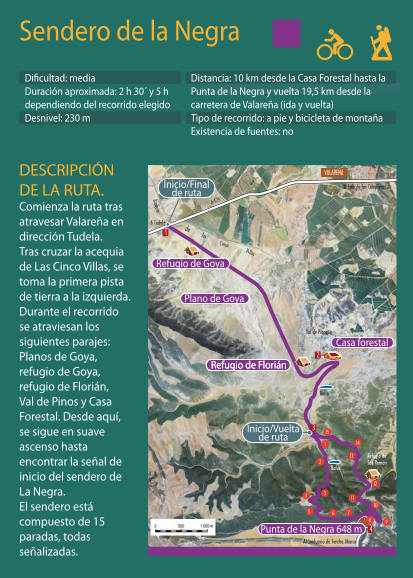
This circular path of about 10 kilometers is ideal for a first contact with Bardena Negra.
To start the trail, you have to drive from Ejea towards Tudela on the A-125. After passing Valareña and the irrigation canal of Cinco Villas, take the first dirt track on the left and follow it.
You can leave the vehicle next to the Florián Refuge (the second hut that we will find) or a little later, next to the forest house.
From there continue following the indications of the wooden posts. It is a circular route of about 10 kilometers, partly by dirt track and partly by footpath. It ascends to the highest point of the Bardenas, the Punta de la Negra on the plain or plateau of the same name, where we will find a geodesic vertex in the middle of a grove with excellent views of the Cinco Villian plain.
RED ROUTE
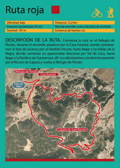
Route of about 12 kilometers following the indications of the posts in red. Like the previous one, you can leave the vehicle in the Florián refuge or next to the Forest house. This route doesn’t ascend to Punta de la Negra itself, but passes just below it, so it has a spectacular view of the Negra Plain (here it would be good to retrieve from FotoCyan the photo “Nature” of the photos that exist in the OT showcase)
RED ROUTE
Route of about 12 kilometers following the indications of the posts in red. Like the previous one, you can leave the vehicle in the Florián refuge or next to the Forest house. This route doesn’t ascend to Punta de la Negra itself, but passes just below it, so it has a spectacular view of the Negra Plain (here it would be good to retrieve from FotoCyan the photo “Nature” of the photos that exist in the OT showcase)
GREEN ROUTE AND YELLOW ROUTE
The Green and Yellow routes have around 40 kilometers each and a certain unevenness, so they are specially designed for mountain biking. Doing the complete routes on foot is only recommended for very experienced hikers and in good physical shape. For hikers with a medium-high level, only one of the two “rings” that make up each route can be done, which can be approximately half of the complete route, about 20km.
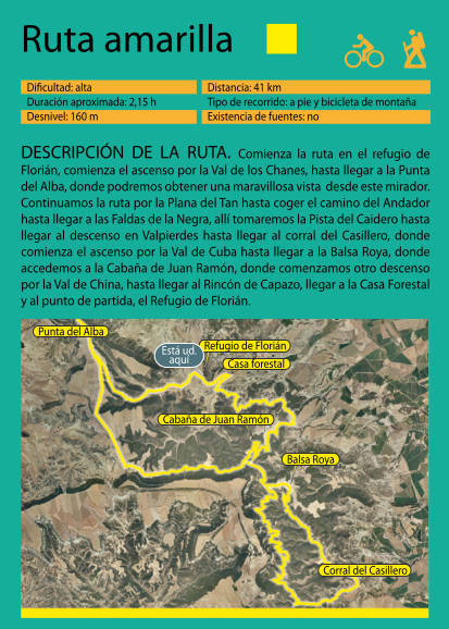
The Yellow Route can be done from the Florián Refuge, where you will find panels with maps of all the routes. You can do one of the two “rings” of about 20km each or ascend to the Punta of Alba, a magnificent viewpoint that overlooks the Santa Margarita gate, the historical and current pass between Bardena Aragonese and Navarre, and return on your steps. In total there are about 11 kilometers between round trip.
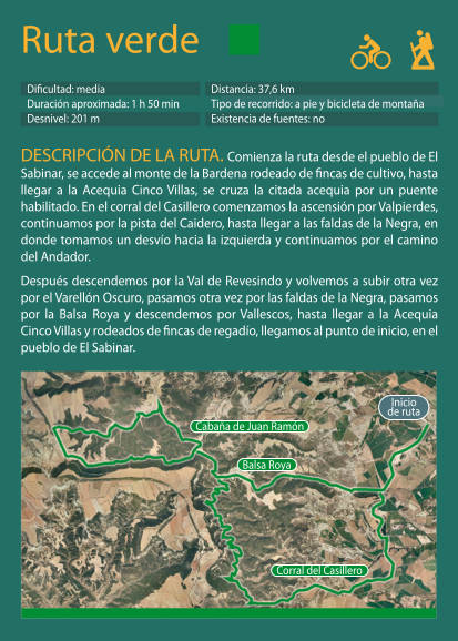
The Green Route, unlike the previous ones, starts from the vicinity of the town of El Sabinar. The start of the route is crossing the CHE-1501 road, which is the one that leads to The Sabinar. As in the other routes, you have to follow the indications of its color, part of the route is common to the previous ones and you can make one of the rings for approximately 20km, or both (37.6km).
Whenever you go hiking, on the plain or in the mountains, you must take into account a series of basic precautions (link https://montanasegura.com/).
The Ejea de los Caballeros Tourist Office is part of the Safe Montain Voluntary Informants Network, an initiative promoted by the Government of Aragon and the Aragonese Mountaineering Federation. Whenever you go hiking, on the plain or in the mountains, you must take into account a series of basic precautions (link https://montanasegura.com/).
There are other hiking routes in Ejea and its surroundings such as the path that runs through The Boalares, next to lake of Gancho or the routes through La Marcuera.
If you want to travel these or other hiking routes through Ejea and the Cinco Villas, you can consult in person at the Tourist Office where we will guide you with maps about them. Applications such as https://en.wikiloc.com/ or the Safe Mountain excursion viewers http://visor.montanasegura.com/ or Aragon Tourist Trails https://senderosturisticos.turismodearagon.com/visor are also highly recommended / or that of the Aragonese Mountaineering Federation.
Information:
Asociación Club de Montaña «Exea»
Address: Polideportivo Municipal (Paseo de la Constitución s/n)
Phone: 976 660 932
E-mail: cmexea@hotmail.com
Anea Tiempo Libre
Phone: 976 667 796 / 656 803 507 (Paloma)
E-mail:
anea@aneatiempolibre.com
Web:
www.aneatiempolibre.com
Anea Tiempo Libre with the collaboration of Inma Zarralanga offer the possibility of visiting natural spaces, taking different routes on foot. These excursions are adapted to the different types of group. Every year in collaboration with the Comarca de las Cinco Villas they organize “Family Walks”.
